
Over the last few years, I have made an effort to become actively involved in shaping the future of Oklahoma City’s urban environment. One particular issue that I have dedicated a great deal of time to is the new boulevard that will replace the former I-40 crosstown bridge. This is Part I of a three-part story about the boulevard and my ideas, hopes and dreams for my city’s new front door. (Click for part II. Part III coming soon)
I-40 and the Boulevard

In 1965, in conjunction with an ill-fated urban renewal plan by architect I.M. Pei to modernize downtown Oklahoma City, a 4 mile elevated interstate highway known as the Crosstown Expressway was constructed along the southern edge of the central business district. Over the next several years this viaduct became a de-facto division between downtown Oklahoma City and the neighborhoods to the south. Even as the inner-city began to revive in the 1990s, the highway continued to be a barrier to growth and reinvestment.

As the city continued it’s suburban growth through the 60s and 70s, more and more drivers utilized the city’s expanding network of expressways resulting in an ever-increasing vehicular load on the structure. By the late 80s, the bridge was handling vehicular traffic in excess of its designed capacity and was rapidly deteriorating. In the following years it became apparent that the aging viaduct was in need of immediate replacement.
Ultimately, and not without controversy, it was decided that the interstate would be reconstructed several blocks south as a below-grade roadway (ODOT’s Alternative D. See below). As part of the environmental mitigation for this project, a tree-lined, pedestrian-friendly boulevard would be constructed in the footprint of the demolished expressway. This would be the new “front door” to a downtown in the midst of a significant urban revival and provide access to many downtown amenities. It would also remove a long-standing barrier and open the door for urban growth to the south of the old expressway.
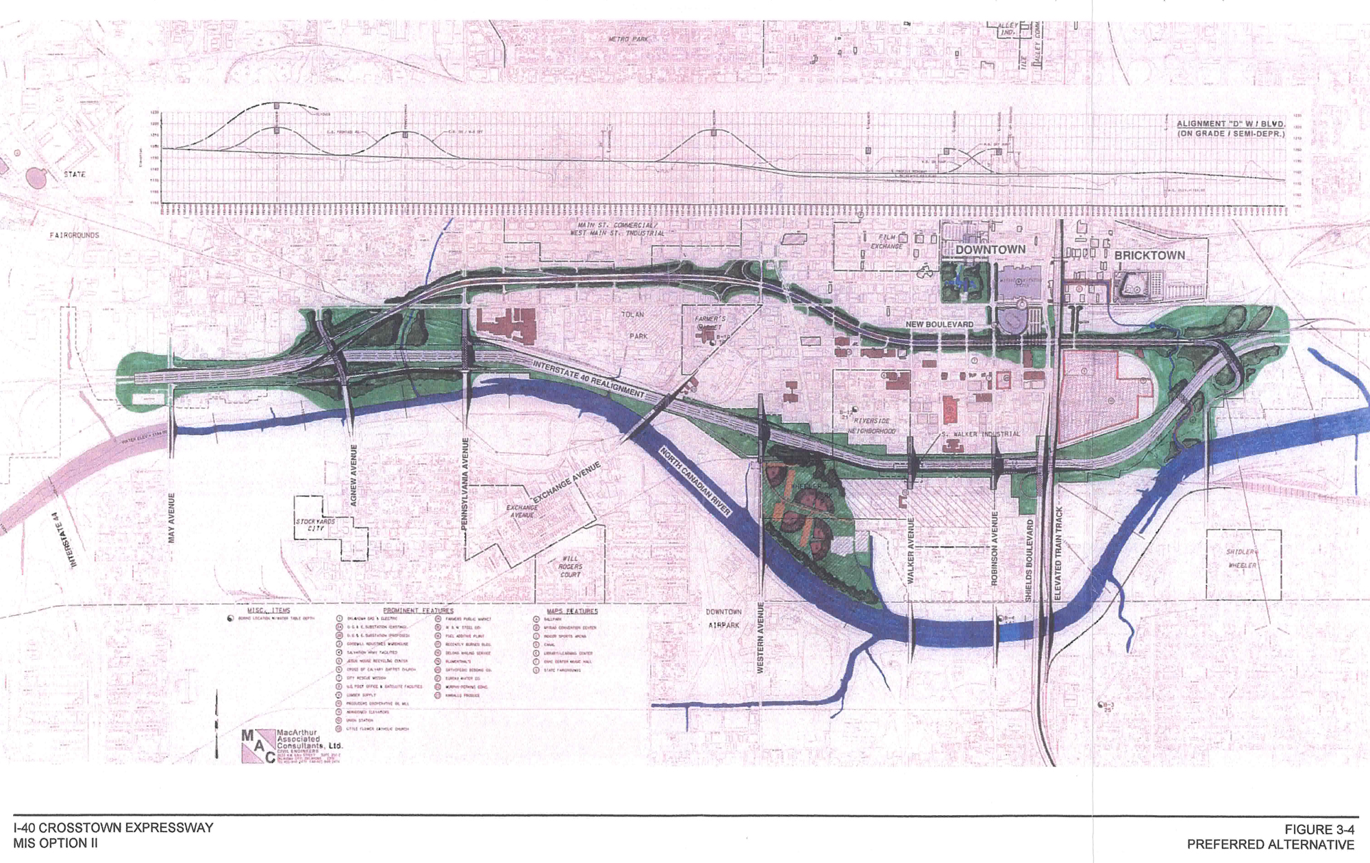
In light of these new redevelopment opportunities, the city commissioned a study, known as Core-to-Shore, in 2006 to provide a framework for redeveloping the neighborhoods between central business district and the Oklahoma River. As a part of this study, the planning team was tasked with developing a conceptual design for the future boulevard that would suggest both its function and its look and feel. Below is an excerpt from the Core-to-Shore final master plan document that briefly describes the vision for the boulevard:
Planning for the Core to Shore study area began with the Oklahoma Department of Transportation’s (ODOT) decision to remove the deteriorating Crosstown Expressway Bridge and relocate I-40 to a new alignment. The structure defines the current southern boundary of the downtown core and separates it from the land and river to the south. ODOT’s preferred alignment for I-40 was one-half mile south of the current route, along the east-west Union Pacific Railroad corridor. During initial negotiations with Oklahoma City, ODOT proposed building a city street after demolishing the deteriorating bridge structure. The demolition of the bridge would, in effect, remove the south boundary to the core, making major changes in the area to the south inevitable. The proposed relocation raised a variety of concerns from downtown and neighborhood interests. In 1999, Oklahoma City completed a study to analyze the issues at hand and propose solutions acceptable to all parties. The study, The Interstate 40 Land Use and Mitigation Study, recommended:
– Connecting downtown to the river by creating a continuous park and open space system surrounded by vibrant new neighborhoods
– A major pedestrian bridge over the new I-40 alignment to minimize the divisive effects of the new roadway
– A new park on the new freeway’s south side to reduce environmental impacts and provide an open space amenity for new and existing neighborhoods south of the railroad alignment
– A new boulevard to replace the old Crosstown Expressway Bridge, providing an iconic entry into the city and an incentive for new downtown development.

The Classen-Western-Reno Conundrum
In the years since Alternative D was choose to replace the aging interstate, it was frequently repeated in the local media that an “at-grade boulevard” would be constructed in the footprint of the old I-40. As a result, the general public was under the impression that the boulevard would replace the crosstown expressway in its entirety from Pennsylvania Aveune to Bricktown. However, this assumption was unfortunately incorrect; as there were several nuances to the new boulevard design that were not necessary common knowledge. One such nuance was a particularly complicated confluence of the boulevard with Classen, Western, & Reno (C-W-R).
To fully appreciate the complexities of this interchange it is important to understand the basic transportation framework that exists in Oklahoma City. The vehicular transportation network is composed of two systems. The primary system is composed of a grid of square mile sections, bounded by main arterial roads, and subdivided by various collector and local streets. Overlaid on this grid is a secondary system of freeways and boulevards that crisscross the metropolitan area.
What makes this particular location in the city so unusually unique and challenging is the convergence of several major thoroughfares within and between both systems. Reno and Western are both significant primary arterial streets and Classen, Exchange, and the new Boulevard are significant boulevards. The close proximity of several important streets and intersections created a design dilemma. When the Crosstown expressway was in existence, this issue was largely mitigated because the busiest thoroughfare, I-40, was elevated over the other streets. Now that an at-grade boulevard was being considered, by all appearances this area had the potential to become much more complicated.

In order to avoid the problematic intersections, the plan was to simply reuse a portion of the old viaduct and maintain an elevated roadway over C-W-R. At the time, this strategy made a certain degree of sense. In Oklahoma City in the late 90s, there was generally little concern about pedestrian amenities and development potential in the dilapidated, western edges of downtown. Through movement of vehicular traffic held first priority. Therefore, it was no surprise that the decision was made to select an auto-centric solution for this area. This plan of action was formalized in the Final Environment Impact Statement dated November 2001 and in the Record of Decision dated May 2002. It was also alluded to in the final document of the subsequent Core-to-Shore study (page 43).
Roundabout?
In 2006, while following the on-going Core-to-Shore study, I became curious about the future of some of the areas just beyond the study area. I was particularly interested what an at-grade boulevard would look like where it interfaced with C-W-R. At this time I was not aware of the FEIS or the Record of Decision and the plan to maintain the elevated portion of the old expressway. I assumed that since the project was several years away from beginning construction, the intersections with C-W-R had not been designed yet. Being a problem-solver by nature and training, I began to sketch out potential solutions. During this process it occurred to me that this location would be ideal for a roundabout.
Much like the iconic traffic circles of many of the world’s great cities, a grand roundabout would create a magnificent civic space, while elegantly resolving the functional aspects of a complex intersection and maintaining urban continuity. A roundabout would link 3 of the city’s important boulevards and provide connectivity between the near-northwest neighborhoods, Stockyards City, and Downtown. It would also unite the Farmer’s Market, Film Row, and other future districts and serve as a western gateway into the core of the city. Instead of dividing this portion of the city like the former elevated expressway, a grand roundabout could in itself be a “bridge” that reconnects the adjacent inner-city neighborhoods.
This is the image I sketched out and posted to OKCTalk.com in 2006:

Friends for a Better Boulevard
 In 2012 the I-40 was opened to traffic and demolition crews began to demolish the old expressway. Now that the viaduct was no longer a barrier, many downtown observers were realizing the potential for areas along West Main Street, SW 3rd, and in particular, the Farmer’s Market area. However, this opportunity would be short-lived. Through a series of circumstances, urban advocates become aware of ODOT’s plans for the west end of the boulevard. It appeared that an elevated expressway would once again isolate these areas from the urban core.By this time, urban redevelopment had expanded beyond the traditional boundaries of downtown and previously overlooked areas, such as Film Row, were in the process of being revitalized.
In May of 2012 I was participating in Better Block OKC where I met Bob Kemper in the MAPS 3 Streetcar Public Information pop-up shop. During our brief conversation, the topic of discussion drifted to the recent news regarding the west end of the boulevard and the controversy it was generating. To my surprise, Bob mentioned a roundabout sketch that had been “making the rounds” and that the concept was generating quite a bit of interest in certain circles. When I asked about the specifics of the sketch, it became obvious to me it was the very same sketch I had posted on OKCTalk.com six years earlier.
Between the brewing controversy on the boulevard and the apparent interest in the concept of a grand roundabout, I realized my off-the-cuff, pie-in-the-sky idea might have some small bit of influence in the boulevard dialogue. Shortly after our chance encounter, Bob launched a citizen advocacy group, Friends for a Better Boulevard, and I set to work developing, refining and eventually publishing the roundabout concept.
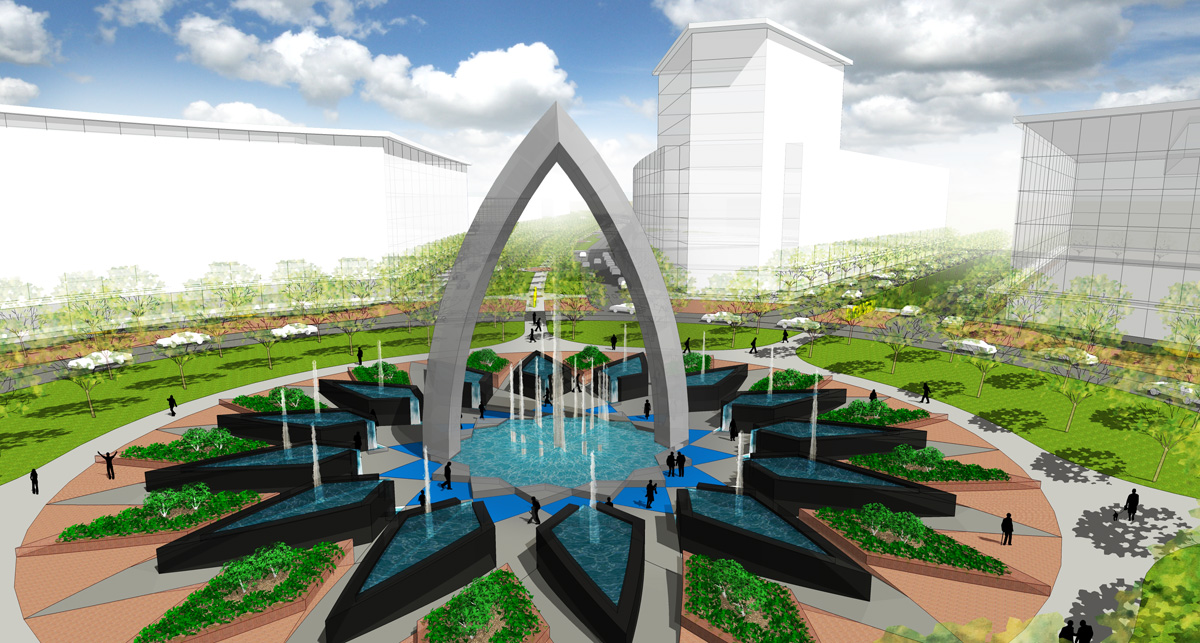
Market Circle
In the initial Market Circle concept, I decided to separate the street/arterial system and the boulevard/freeway system vertically. By depressing both Reno and Western below grade, I was able to bring Classen, Exchange, and the new boulevard neatly together in a roundabout surrounded my parkland. On the surface, this concept reasonably solved the functional issues while creating an attractive and monumental gateway into the city. However, even though it was not as auto-centric as the originally-proposed bridge, the first Market Circle concept was still designed primarily for vehicular traffic.

The revised concept takes into account the myriad of changes that have taken place in this area since the initial idea was proposed and recognizes the importance of pedestrian and development opportunities. The needs of downtown access must be balanced with walkability, development potential, and the viability of fledgling urban neighborhoods. The revised version of the Market Circle is an attempt to strike that balance.
The goal of the Market Circle concept is to take the two overlapping street systems and mesh them together without any form of grade separation. This is achieved by modifying the alignments of Reno and Western within the street grid and shifting the intersections of these secondary streets away from the circle. In the case of Reno, it is simply re-routed one block south onto the alignment of SW 2nd street between Shartel and Clegern. Western is a bit more difficult. Due to the proximity of Classen Boulevard, Western in this area is not a significant through street north of Sheridan. Taking that into account, northbound Western is terminated where it meets the re-rerouted Reno and southbound Western is terminated at Sheridan. Traffic on Western south of Reno is routed to and from Classen via Exchange. By making these adjustments, I was able to resolve much of the complexity in bringing together so many roadways while preventing growth-stifling grade separations.
Overall, the Market Circle concept is a viable solution that balances multiple, competing goals:
- Accommodates large-volume vehicular traffic flow.
- Encourages pedestrian activity.
- Promotes connectivity between emerging districts and existing neighborhoods.
- Provides development opportunities.
- Creates a sense of place with a unique, local landmark.
- Establishes a western gateway to downtown.
- Provides an opportunity for public art.
Below are images of the Market Circle concept. Click on the images for larger versions. There complete presentation can be downloaded here (28MB PDF).


The Rest of the Story…?
My part of the story ends here (for now). Following the establishment of Friends for a Better Boulevard and the publication of the Market Circle concept, the local news media outlets began to devote a significant amount of coverage to the ongoing boulevard controversy. In the months following meetings were held, interviews were given, and stories were written. The links that I have complied below that, read together, should tell the rest of the boulevard story through January of 2013. However, the story is still being written. Look for Part III in the coming weeks.
July 16th, 2012 – NewsOK.com: Critics attack Oklahoma City boulevard designs, say elevation will hamper Core to Shore development
July 19th, 2012 – The Oklahoman Editorial: Oklahoma City Boulevard design gets a bumpy response
July 24th, 2012 – Oklahoma Gazette: Street fight – Opposition to initial plans for the downtown boulevard call a bridge counterproductive.
July 26th, 2012 – The Journal Record: Elevations: Roundabout Dreams
July 28th, 2012 – NewsOK.com: Oklahoma City group questions highway engineers’ roundabout design
July 30th, 2012 – News9.com: City Council To Get Update On Controversial OKC Boulevard Project
July 31st, 2012 – NewsOK.com: Oklahoma legislators monitor downtown Oklahoma City boulevard debate
July 31st, 2012 – NewsOK.com: Boulevard fight represents divide between traditional road design, modern urban planning
City Council Meeting – July 31st, 2012
July 31st, 2012 – City Council: Agenda and Video ODOT & Public Works Boulevard Presentation

July 31st, 2012 – News9.com: Oklahomans Express Concerns On OKC Boulevard Project
August 1st, 2012 – NewsOK.com: Oklahoma City will hire independent engineer to look at downtown boulevard options
August 6th, 2012 – NewsOK.com: Possible roundabout has iconic art potential for Oklahoma City’s boulevard
August 7th, 2012 – Oklahoma Gazette: Road warriors – A flurry of options and disagreements arises over a proposed downtown boulevard.
Friends for a Better Boulevard Town Hall Meeting – August, 13th, 2012


August 14th, 2012 – News9.com: Hundreds Attend Meeting Concerning OKC Boulevard Project
August 21st, 2012 – NewsOK.com: An Oklahoma City urban revival meeting prompts cheers
ODOT Public Meeting – August 21st, 2012
August 21st, 2012 – ODOT Public Meeting: Presentation & Handouts


August 21st, 2012 – NewsOK.com: Oklahoma officials: We’re listening to you on downtown Oklahoma City boulevard
November 26th, 2012 – NewsOK.com: Design compromise for Oklahoma City Boulevard to be revealed at December meeting
November 30h, 2012 – NewsOK.com: Oklahoma City Boulevard recommendation has raised portion only at Western
ODOT Public Meeting – December 3rd, 2012
December 3rd, 2012 – ODOT Public Meeting: Presentation & Handouts


December 3rd, 2012 – NewsOK.com: Recommended Oklahoma City Boulevard design meets skepticism
December 11th, 2012 – Oklahoma Gazette: Street fight – City leaders hope a recommended design for a downtown boulevard will quell opponents who favor other options
December 18th, 2012 – Oklahoma Gazette Bumpy Road – Opposition mounts against a plan to elevate a section of the future downtown boulevard
January 7th, 2013 – NewsOK.com: Oklahoma City Council set to make decision on boulevard design
January 8th, 2013 – NewsOK.com: Oklahoma City Council approves compromise plan for downtown boulevard
January 9th, 2013 – Oklahoma Gazette: Road test – After lengthy debate, OKC city council approves a controversial plan for a downtown boulevard
Oklahoma Energy Grand Prix
Updated 1-13-2014
Thanks for reading,
![]()
